myfiber Portal
The myfiber portal is a user-friendly web application that provides interactive access to fiber infrastructure data paired with geolocation information, powered by the myfiber API.
Map
The Map section allows you to explore fiber coverage by searching an address or interacting directly with the map.
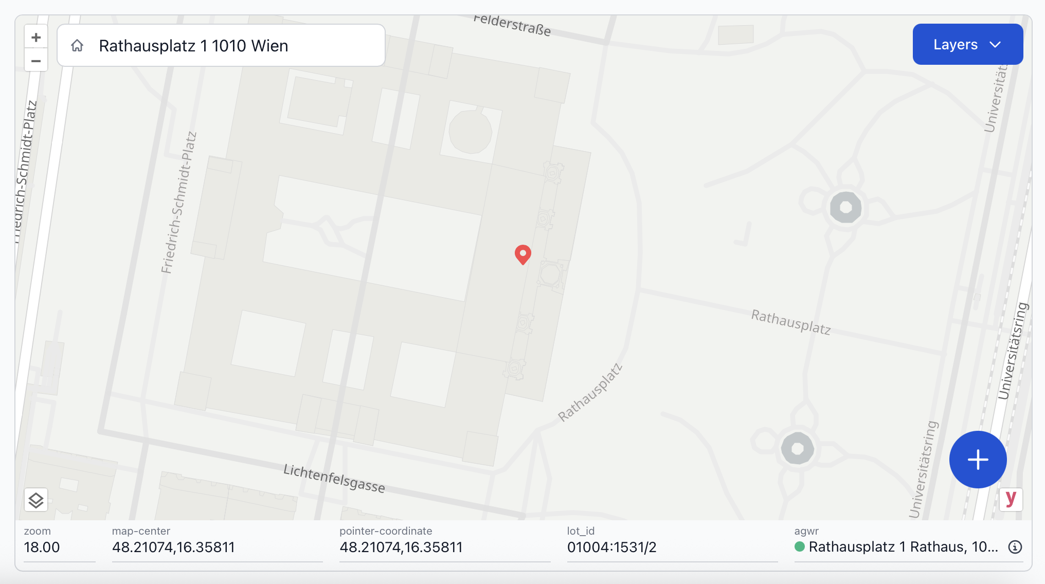
Searching an address or clicking anywhere on the map places a marker at that location. Relevant information is displayed below the map including:
zoom- the current zoom level of the mapmap-center- the coordinates for the center of the map displaypointer-coordinate- the coordinates of the placed markerlot_id- the cadastral lot ID that contains the markeragwr- the nearest matching address to the marker in the AGWR
Possible Actions with Info Below the Map
- Re-center the map by typing coordinates into
map-centerand pressing Enter . - Click the icon to quickly copy any data field.
The agwr address under the map represents the nearest building address in the AGWR to the marker's position.
The colored circle next to the AGWR address indicates whether the marker is located:
- within the same lot as the AGWR address
- in a different lot from the AGWR address
Hover over the agwr address to reveal detailed address information about the nearest matched AGWR address to the marker.
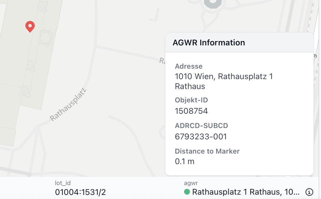
The agwr data includes:
Adresse- Closest building address to the markerObjekt-ID- Unique building object numberADRCD-SUBCD- Building address IDDistance to Marker- Distance in meters from the marker to the building in the AGWR
Use the icon (bottom left) to switch between basemap options: Open Street Maps, satellite view, and BEV Kataster (showing parcel boundaries).
Additional map layers such as access nodes, NTUs, building footprints, infrastructure elements, or coverage components can be toggled on/off under Layers.
Legend
| Map Markers | Types |
|---|---|
| Site | not suspended suspended |
| Access Node | planned construction operation |
Infrastructure
The Infrastructure section displays and manages data for the subsections: Sites, Links, POPs, and FCPs.
Filtering and Adding Data
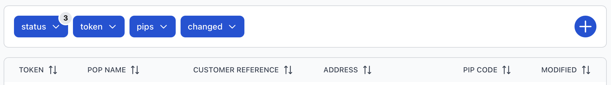
Each subsection shows a list of data, which can be filtered by:
status- the production/operational process statustoken- the milestone status of the process for the physical and/or electrical layer (varies by subsection)pips- specific PIPs may be selectedchanged- the date when the data was last modified
Additionally, you may click the button to download a tsv file of the list, or add a new entry.
Record Status Icon
In front of each of the listed records is a status icon (![]() or
or ![]() ) consisting of:
) consisting of:
- a vertical bar - corresponds to the
statusof the record - one or more horizontal bars - represents the
tokenattributes available for each subsection
In most sections, just one token attribute is provided, so only one token bar is displayed (![]() ).
).
For "Sites", there are two token attributes: token L1 (physical layer) and token L2 (electrical layer). These are layered as follows:
![]()
The colors for each of the attribute's bars will vary depending on its value. The possible values and colors for the attributes will be covered in each subsection below.
Sites
The Sites section is where location information for a fiber connection can be added and maintained.
Sites may be filtered by the attributes defined in the Infrastructure section. The token attribute is split into two separate
attributes under "Sites":
L1 token- the status of the physical fiber connection (or the physical infrastructure progress)L2 token- the status of the electrical fiber connection (or the installation and service status of the customer's NTU)
The small status icon before each record illustrates values for three attributes: status, L1 token, and L2 token.
Below are all possible values with their respective colors and descriptions.
Sites Status Icon
| Description | |
|---|---|
| active | operational process is ongoing |
| completed | process is expectedly permanently stopped |
| started | operational process has begun |
| suspended | process is temporarily paused |
| terminated | process is unexpectedly permanently stopped |
| Description | |
|---|---|
| accepted | site is accepted (in the planning phase and likely to be built) |
| built | connection established to fiber infrastructure and site is operational |
| canceled | rollout of fiber infrastructure has been canceled for the site |
| confirmed | site is confirmed (it is in the planning phase and will be built) |
| indelivery | site is going to be built in the near future |
| mounting | site is under construction and going to be mounted |
| reserved | site is reserved (or prepared for later usage) |
| unclear | site status of the fiber connection is unknown |
| Description | |
|---|---|
| active | NTU is installed and provides an active service to the customer |
| connected | NTU is installed at the customer's site (without service) |
| disconnected | NTU is not installed |
Clicking on a site record opens a detail page containing a map and several panels with site information.
The "Customer Site" panel is on the left and contains the map with customer site data beneath it. Hover over the icon beneath the map to: revise the data, change the location, create a link (between the site and a POP), or delete the site.
In the "Nearby Site" panel on the right, all sites within 50 meters from this site are shown.
If any links are connected to this site, corresponding "Fiber Link" panels appear below the "Customer Site" panel. From the icon in a link panel, you can: go to the link data, revise the link data, or delete the link.
Links
Links represent the fiber connection between sites and POPs. A site can have multiple links, each connecting to different POPs.
The list of links can be filtered by the features specified under "Infrastructure". The descriptions for the status and token values with their assigned colors are listed below.
Links Status Icon
| Description | |
|---|---|
| active | operational process is ongoing |
| completed | process is expectedly permanently stopped |
| started | operational process has begun |
| suspended | process is temporarily paused |
| terminated | process is unexpectedly permanently stopped |
| Description | |
|---|---|
| connected | link is connected (site is built and operational) |
| idle | link is idle (automatically created by system) |
| indelivery | link will be usable in the near future |
| prepared | link is in a prepared state, but not yet in delivery |
| unclear | link is in an unclear state |
Links are created within the "Sites" section, on the "Customer Site" panel of the site's detail page.
Access the detail page for a link by clicking on a record. The map shows the link as a line segment between the site and the POP.
Additional information for the link is provided under the map.
Hover over the under the map to do any of the following: revise the link data, go to the site data, or delete the link.
POPs
The POPs (Point of Presence) section lists network aggregation sites where fiber connections converge. Each POP acts as a central hub that connects sites with links.
POPs can be filtered by the attributes listed under the Infrastructure section.
POPs Status Icon
| Description | |
|---|---|
| active | operational process is ongoing |
| completed | process is expectedly permanently stopped |
| started | operational process has begun |
| suspended | process is temporarily paused |
| terminated | process is unexpectedly permanently stopped |
| Description | |
|---|---|
| built | POP is built |
| planned | POP is planned |
Clicking on a POP record opens a detail page with its location on the map and its associated details beneath it.
Hover over the below the map to: revise the POP data, change the POP's location, or delete the POP.
FCPs
FCPs Status Icon
| Description | |
|---|---|
| active | operational process is ongoing |
| completed | process is expectedly permanently stopped |
| started | operational process has begun |
| suspended | process is temporarily paused |
| terminated | process is unexpectedly permanently stopped |
| Description | |
|---|---|
| built | FCP is built |
| planned | FCP is planned |
Coverage
Access Nodes
Access nodes represent locations within fiber coverage. These are often referred to as "Homes Passed", however this terminology may evolve within OFAA as standardization efforts are in progress.
Coverage access nodes can be filtered by the same attributes listed under the Infrastructure section (status, token, pips, and changed). Additionally, you can hover over the nearby to download a tsv file of all access nodes or create an access node.
The status icon portraying the status and token attribute values is also displayed in front of each record in this list. The values and assigned colors for both attributes in the icon are described below.
Access Nodes Status Icon
| Description | |
|---|---|
| active | operational process is ongoing |
| completed | process is expectedly permanently stopped |
| started | operational process has begun |
| suspended | process is temporarily paused |
| terminated | process is unexpectedly permanently stopped |
| Description | |
|---|---|
| construction | access node is under construction |
| operation | coverage is available at this location |
| planned | coverage for the location is planned |
Clicking on a record opens a detail page with its location on the map and its associated details below it.
Hover over the under the map to: revise the access node data, change the access node's location, or delete the access node.